by Ruth Wyman Neagle • Treasurer of the MPA board
Are you looking for a convenient location that has everything you could possibly want for a day of hiking? A place where the whole family can take a stroll to beautiful waterfalls along an accessible path, but also offers opportunities for rock scrambles and amazing views? All less than an hour from Moose Pond? The Moat Mountain Ridge that overlooks North Conway is your place! “The Moats” consists of three main peaks – South, Middle, and North – which burned in the 1850’s and are now rocky open summits. There are two trails on the ridge The primary trail follows the north-south axis of the Moats, appropriately named the Moat Mountain Trail. The Red Ridge Trail ascends one of the many spurs off the Moats ridge. More on that later!
At the base of North Moat, where Lucy Brook runs over and through ledges and potholes, you will find the sparkling and swirling cascades of Diana’s Baths. The indigenous Abenaki name for the area translates to “Water Fairies’ Spring.” With dragonflies flitting above the currents and mists, one can almost see the fairies dancing in the sunlight. European settlers, likely the Lucy family, renamed the area for Diana, the goddess of nature. The trail, which is also the northern start of the Moat Mountain Trail, is about one mile of well-graded, hardpack gravel, suitable for anyone with limited mobility, as well as strollers and wheelchairs. After that first mile, the Moat Mountain Trail becomes typical New Hampshire rocks, roots, and steepness, so be prepared if you intend to go further. Parking for Diana’s Baths is on West Side Road in North Conway.


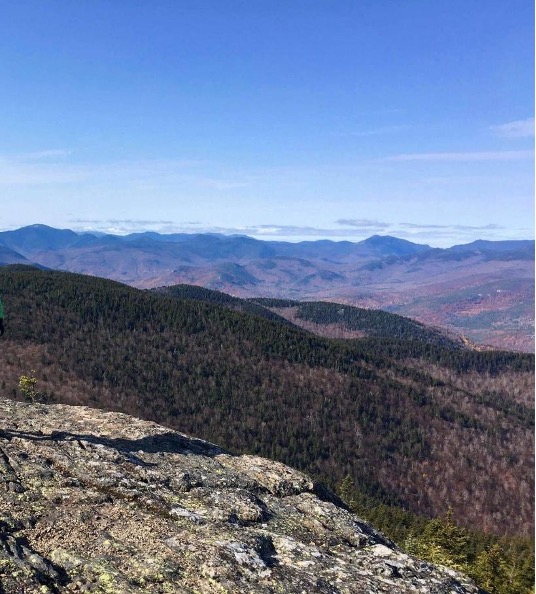
South Moat is a “moderate” hike of 2.6 miles (5.2 round trip), and 2300 feet of elevation gain. Be advised that “moderate” doesn’t necessarily mean “easy.” The trail is steep and rocky in sections, and a recent reroute crosses an old (stable) landslide where footing can be tricky. Be careful following the route across open ledges. From there, you get your first views back across the Kancamagus Highway to Chocorua and other southwest features. Continuing on and up the ledges, you reach the summit of South, where the views are worth your efforts! To the east is our own Pleasant Mountain, and, turning counterclockwise, you see the Baldfaces in Evan’s Notch, Kearsarge North, the Presidentials, North and Middle Moat, and, finally the vast expanse of the Pemi Wilderness and numerous White Mountain peaks. Return the way you came to your car parked at the trailhead on Passaconaway Road in Conway, or continue on to Middle and North Moat.
The views are worth your efforts!
If you left a car at Diana’s Baths and are making a full traverse over South, Middle, and North Moat, don’t linger too long at the summit of South. You have a long way to go, and many more views to take in! It’s a short 0.6 mile walk off the South summit, down into a wooded col, and up onto the open ledges of Middle. The views continue to be expansive and awesome. From here, you can add Middle as an out and back from Passaconaway Road, or bypass Middle on your traverse to North. The summit of North Moat is a rocky cone, and is almost 500 feet higher than South Moat. Gaining that summit requires attention to trail markers and a significant descent to a wooded col. You pass the turn to Red Ridge Trail, traverse up and down along the ridge, and then scramble up several steep sections of ledge. You’ll feel on top of the world at the summit of North Moat! At this point your hike has covered 5.3 miles, and a total of 3,250 feet of elevation gain. You have another 4.3 miles down the face of North Moat to reach Diana’s Baths and complete your traverse. The descent is quite eroded, and can be a bit treacherous after rain or any other time the exposed rocks are wet. Watch your step and proceed with care until you reach and cross Lucy Brook (difficult in high water), pass the lower end of the Red Ridge Trail, and join the graded path at Diana’s Baths. The whole traverse is 9.6 miles, and can be done south to north (as described), or north to south (in reverse).
Another option if you’d like to reach North Moat, but don’t want to do the traverse, would be to make a loop with the Red Ridge. That trail begins at an intersection with the northern terminus of the Moat Mountain Trail, after passing Diana’s Baths. Red Ridge Trail turns left off the Moat Mountain Trail, crosses Lucy Brook (difficult in high water), and follows moderate grades. Don’t be fooled! As the trail approaches the ridge, there are several very steep sections where you may have to pull yourself up and over a couple of ledges. Red Ridge juts out from the ridge between Middle and North Moat, and offers fabulous views. Turn right at the intersection with the Moat Mountain Trail and continue to North Moat, descending the Moat Mountain Trail. The Red Ridge / Moat Mountain loop is 9 miles with 2700 feet of elevation. It’s just as challenging as the traverse, but offers a different perspective and an alternate approach.
As always when hiking in the backcountry, be prepared with the Ten Essentials, and consider purchasing a Hike Safe Card to support our local Search and Rescue Teams. Leave your hiking plans with a friend or family member, and let them know when you have completed your hike safely. Happy Trails!!

