by Ruth Wyman Neagle – Middle Basin resident • MPA board member since 2021 • 50+ years on the lake
We all know there are many ways to enjoy being in or on the waters of Moose Pond — swimming, boating, fishing and water skiing. But there is another way to appreciate our lake, from high above on Pleasant Mountain. The extensive trail network maintained by Loon Echo Land Trust provides many vantage points from which to view Moose Pond. Looking down from Bald Peak, walking the North Ridge, or having a snack at the Ledges on the way to the Main Summit puts Moose Pond front and center. We are so fortunate to have this hiking resource available to us – and so close!
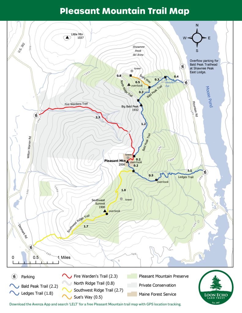
With all the trail choices it’s easy to put together outings ranging from a fairly easy walk to a full challenging day. The Ledges Trail leads to an open outcrop with a wonderful view of the south basin and makes a nice destination lunch spot for those new to hiking or looking for something suitable for little ones. Continuing on past the ledges, the trail loops around and up to the Main Summit from where hikers can see the many ponds on the west side of Pleasant Mountain and, on a clear day, a fabulous view of the White Mountains. A longer hike with greater elevation gain is the loop which summits Big Bald Peak via the Bald Peak Trail, continues to follow the Bald Peak Trail to the Main Summit, and descends via the Ledges Trail. From Bald Peak and along the ridge there are several outlooks with views of the north and middle basins, and hikers really get a sense of the shape and size of Moose Pond. Maybe you can identify your shoreline, or see friends making toy-like wakes from miniature boats! Once you reach the Main Summit, descend via the Ledges Trail with the islands and coves of the south basin right at your feet. I like this loop for solo hikes since a car spot is not necessary — park at either Bald Peak or Ledges trailhead and walk (carefully) along Mountain Road to complete the loop. If you do have a second car, and you are up for a full day, then instead of descending via the Ledges Trail, follow the Southwest Ridge Trail south and west to its trailhead on Denmark Road. I like the Southwest Ridge Trail for its wide expanse of views and exposed descent. On a sunny winter afternoon this route is truly spectacular, with miles of open ledges and outcrops and the low sun warming your face.
There are other trail options that can either extend your day or offer a shorter hike. Sue’s Way off the Bald Peak Trail scrambles up a rocky cleft just south of Shawnee Peak’s Upper Appalachian ski trail, passes close to Shawnee’s yurt, and leads to some fabulous blueberry picking. A nice short hike option is the Needle’s Eye, a narrow chasm in the rock with a waterfall at its head. Follow the left turn sign off the Bald Peak Trail but be ready for some very tricky footing. It can be slippery but entering the cool misty air of the “Eye” is an awesome experience. Please be extra careful if there is ice (which often lasts into June) and keep a hand on children and dogs!
There is one more trail that accesses the Main Summit, the Fire Warden’s Trail, which begins on the west side of Pleasant Mountain with a small parking area on Wilton Warren Road. This trail is longer, with less elevation gain, and thus appeals to hikers looking for less of a cardio workout. There are no views until the summit, but since it is so sheltered it is a great choice for a winter hike, and there are well maintained bridges over several stream crossings.
Happy Hiking!

A few fun facts: The Loon Echo Land Trust owns around 2,000 acres on the eastern side of the mountain. The Nature Conservancy protects 1,400 acres on the western slope, and the Maine Forest service owns 20 acres on the summit. Wardens manned the fire tower on the Main Summit from the 1920s to the 1960s to spot signs of smoke or fire and welcomed hikers who were brave enough to climb the ladder. The tower was 48 feet tall when first built but was then lowered to 36 feet in 1960. • In 1860, the summit of Pleasant Mountain was burned over. In some spots trees have managed to regenerate but vegetation is mostly low shrubs and blueberry bushes. Pleasant Mountain was once called House Peak for the guest house that stood on top from 1845 to 1860. The house was rebuilt after the fire as a larger hotel which operated intermittently from 1873 to 1907. The Portland Museum of Art owns a painting by Charles Beckett which shows the hotel and the scarred remains from the fires. I don’t know how accurate the representation is supposed to be, but I believe the carriage road in the painting is today’s Fire Warden trail.
For more information please refer to the Loon Echo Land Trust website, the Portland Museum of Art, and the 1995 Denmark Historical Society Newsletter.

